Water Management and Flood Defense Systems in European River Basins
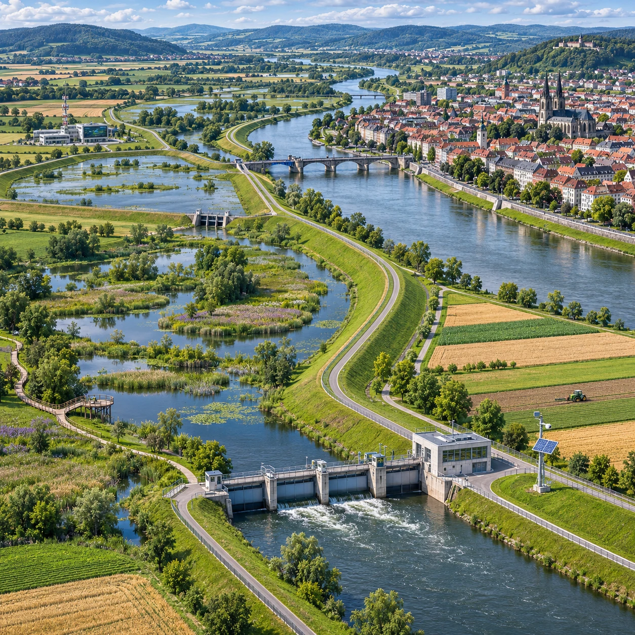
Flood risk in Europe rarely stops at a city boundary or national border. Rainfall, snowmelt, reservoirs, tributaries, transport links, and settlements all interact across a river basin, making flood management a shared infrastructure and environmental challenge.
Effective planning combines physical defenses with land-use decisions, ecological restoration, and coordination between the communities upstream and downstream. The right mix depends on the river, the people and assets exposed, and the level of protection a project can realistically provide.
Why river basins are central to European water management
A river-basin approach plans for water across the full area that drains into a river and its tributaries. This matters because interventions upstream can change flood flows, water quality, and ecosystem conditions downstream.
European river basins connect cities, farms, industry, ports, roads, railways, and habitats. A river may cross several administrative regions or countries before reaching the sea. Managing one stretch in isolation can shift risk elsewhere: a barrier may protect one settlement while changing where floodwater spreads, and drainage improvements can move runoff into a river more quickly.
River-basin management planning therefore considers more than flood protection. It links flood risk management with water quality, groundwater, land use, and the health of rivers and wetlands. In the European Union, the Water Framework Directive and Floods Directive provide important frameworks for coordinating water objectives and flood-risk assessment. The European Commission describes these policies through its overview of EU water legislation.
For infrastructure planners, the basin is the practical unit for asking three questions: where does water come from, where can it safely go, and who or what is exposed along the way? Those questions help identify projects that reduce risk without simply transferring it.
The main components of flood defense systems
Flood defense systems use structures and operating rules to reduce the chance that high water will reach people, buildings, and critical infrastructure. Common components include levees and flood barriers, dams and reservoirs, drainage networks, and controlled storage areas.
Levees and embankments hold back river water along vulnerable stretches. Movable barriers can close openings or protect specific urban areas, while pumps and drainage channels remove water from behind defenses. Dams and reservoirs may store some inflow and release it later, subject to operating rules, reservoir capacity, water supply needs, and ecological requirements.
These measures serve different purposes, so they need to work as a system. A levee can reduce frequent flooding in a protected area, but it cannot eliminate risk: water may overtop or breach it, and development behind the levee can increase the consequences of failure. Reservoirs also have limits. Their value depends on available storage before a flood, forecast quality, dam safety, and competing uses such as drinking water, energy, and river flows.
- Linear defenses: levees, embankments, and flood walls that protect defined corridors.
- Barriers and gates: movable structures that close river or tidal openings during high-water conditions.
- Storage infrastructure: reservoirs and designated retention areas that temporarily hold water.
- Drainage and pumping: systems that manage rainfall and water trapped behind defenses.
Engineered defenses require inspection, maintenance, and clear operating responsibilities. Choosing a structure for reliable protection means accepting long-term costs and the need to plan for residual risk if the design capacity is exceeded.
Working with rivers and floodplains
Nature-based solutions reduce flood impacts by making space for water and supporting natural processes. Restored floodplains, wetlands, and river corridors can complement engineered defenses, though their effectiveness depends on local terrain, soils, and the size and timing of floods.
Floodplains temporarily store water and can slow its movement through a basin. Wetlands may also support habitats, improve water retention, and contribute to water-quality goals. River restoration can reconnect a channel with parts of its floodplain, while removing or setting back selected embankments can create room for high flows away from densely populated areas.
These measures are not a universal substitute for barriers or levees. In a compact city with limited open land, a restored wetland may not provide enough protection for nearby homes or transport infrastructure. Conversely, relying only on hard defenses can narrow the river corridor and leave fewer places for floodwater to spread safely. A robust project often combines approaches: structural protection around critical assets, with floodplain storage and ecological restoration elsewhere in the basin.
Land is the central practical constraint. Floodplain restoration may require compensation, changes to farming practices, or agreements with landowners. Projects work better when planners identify suitable storage areas early and involve residents, farmers, and environmental agencies before designs are fixed.
Planning across borders and sectors
Cross-border coordination is essential when a river basin spans multiple countries because decisions about water storage, defenses, and land use in one jurisdiction can affect flood levels elsewhere. Shared planning helps align evidence, project timing, and operating procedures.
Coordination involves national water authorities, local governments, infrastructure operators, emergency services, environmental agencies, and communities. Operators of dams, bridges, ports, railways, and water-treatment facilities need to understand how a proposed project could alter flows or affect access and service continuity. Environmental agencies can identify protected habitats and water-quality constraints, while local authorities understand development plans and vulnerable sites.
Countries may share flood maps, hydrological data, forecasts, and river-basin plans through international commissions and bilateral agreements. Yet cooperation is not automatic. Data may use different formats or measurement standards, and national priorities can diverge over land use, investment, or reservoir operations. Agreeing on common scenarios and responsibilities before construction reduces the risk of fragmented infrastructure.
A useful project sequence is to map basin-wide exposure, compare structural and nature-based options, assess effects upstream and downstream, and then agree on who funds, builds, operates, and maintains each component. That sequence links engineering decisions to wider river-basin management rather than treating a project as a stand-alone asset.
Designing projects for climate resilience
Climate-resilient flood projects account for changing rainfall, river flows, and uncertainty over a structure’s service life. Planners should test how designs perform under a range of plausible conditions, not rely on a single historical flood record.
Climate change can alter the frequency, intensity, or seasonality of heavy rainfall and flooding, with impacts varying by location and basin. Long-lived assets such as levees, dams, bridges, and drainage systems may remain in service for decades, so their design needs to consider future conditions as well as current standards. Climate projections are not exact forecasts for a specific flood, but they help assess whether a project remains effective across different scenarios.
Resilience also depends on maintenance and adaptability. A project can include space to raise a levee later, reserve land for a future diversion or storage area, or use monitoring to trigger changes in reservoir operations. Such flexibility has a cost: reserving land or building adaptable structures may require more investment now, while delaying all action can leave communities exposed to changing risks.
Planners should assess how flood defenses interact with drought, water supply, sediment movement, and habitat needs. A reservoir operated solely to create flood storage, for example, may conflict with other water uses. Basin-wide modelling and regular review help reveal these trade-offs and update assumptions as evidence changes.
Delivery challenges and practical trade-offs
River-basin projects are difficult to deliver because they require long-term funding, land access, environmental review, and agreement among many stakeholders. Successful planning weighs protection benefits against impacts on river function and local communities.
Construction costs are only part of the budget. Levees, gates, pumps, reservoirs, and monitoring systems all need inspection, repair, and eventual renewal. Nature-based measures may have lower structural complexity, but they still require land agreements, ongoing stewardship, and monitoring to confirm that the intended storage or habitat benefits persist.
Environmental effects also need careful assessment. New barriers can restrict fish movement or alter sediment transport; drainage changes can affect wetlands and groundwater; and floodplain storage can change how land is used. On the other hand, well-planned restoration can create habitat and improve river connectivity while contributing to flood management. Results depend on design and location, so environmental benefits should be assessed rather than assumed.
Three recurring mistakes undermine delivery:
- Designing for one return period alone: A structure may meet a target yet leave people unaware of the risk from larger floods. Test overtopping, breach, and residual-risk scenarios, and avoid treating any defense as absolute protection.
- Evaluating a project only at its construction site: This can miss downstream effects or upstream storage opportunities. Compare alternatives across the basin before selecting a preferred design.
- Leaving landowners and operators until late in planning: This can delay approvals and weaken maintenance arrangements. Involve them early, clarify responsibilities, and address compensation and access requirements.
The practical aim is to protect people and essential services while keeping rivers able to function. That means making trade-offs explicit: where water is held, which assets receive protection, what ecological changes are acceptable, and who carries the long-term costs.
Frequently asked questions
What is a river-basin approach to flood management?
A river-basin approach plans flood-risk measures across the full area drained by a river and its tributaries. It considers how upstream land, infrastructure, and storage affect communities and ecosystems downstream.
How do structural defenses differ from nature-based solutions?
Structural defenses use built assets such as levees, barriers, dams, and pumps to manage water or protect specific places. Nature-based solutions use floodplains, wetlands, and river restoration to store or slow water and support ecological functions. Many projects combine both.
Why is cross-border coordination important for European river basins?
Rivers carry water across national boundaries, so actions in one country can influence flood levels, water quality, and ecosystems in another. Shared data, aligned plans, and agreed operating procedures help manage those effects.
How can flood defenses affect ecosystems and local communities?
Defenses can reduce flood exposure for homes and infrastructure, but they may also alter river flows, sediment movement, habitats, and access to land. Early consultation, environmental assessment, and a mix of measures help balance protection with community and ecological needs.